NERC-Airborne Research Facility (ARF)
- Introduction
- History
- Instruments
- How to find ARF data
- Help to read ARF data
Introduction
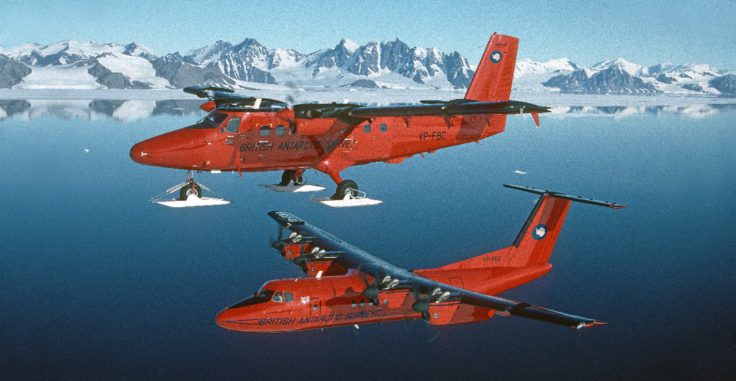
NERC Airborne Research Facility formerly known as Airborne Research & Survey Facility (ARSF) and Airborne Remote Sensing Facility collect data from one of two Twin Otter research aircraft (or a Dash 7) operated by British Antarctic Survey. Data are processed by the ARF data analysis team at the Plymouth Marine Laboratory and are archived at the Centre for Environmental Data Analysis (CEDA). Currently the NERC ARF provides radiometrically corrected hyperspectral data from the AISA Fenix and Owl instruments; ground height information from the Leica ALS50-II; and digital photography.
Airborne remote sensing provides an efficient method for the rapid collection of data over a specified area; consequently it is a cost effective means of monitoring the terrestrial, freshwater, marine and atmospheric environments, provides a transitionary scale with which to validate satellite data and enables the rapid acquisition of data for sudden or unexpected events, such as floods and earthquakes. Since 1983 the facility has supported a wide range of applications, including environmental science, geomorphology, archaeology, ecology, geologic surveying, pollution control and disaster management.
History
1983

A Piper PA31 Navajo Chieftain aircraft was acquired based at Kennington Airport, and converted to survey configuration, initially deploying a WILD RC-8 metric survey camera. A number of aviation services operated the aircraft, providing pilot and instrument operator as required, with an Operations Manager/Navigator employed by NERC. For a number of years a range of digital spectrographic imaging instrumentation - including a Daedalus 1268 Airborne Thematic Mapper (ATM) - was demonstrated, and a WILD RC-10 camera replaced the RC-8.
2000
Dornier 228 research aircraft (G-ENVR).
The Do 228 is a twin turbo-prop powered, non-pressurised, shoulder-wing monoplane with rectangular-section fuselage and a double passenger/cargo door. The aircraft was used in the fields of optical remote sensing, oceanography, atmospheric and earth science research. A range of sensors were installed, for example metric cameras, multi- and hyperspectral scanners, optoelectronic and infrared line scanners, microwave radiometers, synthetic aperture and side-looking airborne radar, scatterometers, LIDAR, etc.
2009
The ARSF relocates to new premises in Gloucester Airport. The new facility gave additional calibration and workshop space.
2016
ARF is now operated by the British Antarctic Survey in Cambridge, using two Twin Otter research aircraft (or a Dash 7). Data are processed by our data analysis team at the Plymouth Marine Laboratory and are archived at the Centre for Environmental Data Anaylsis (CEDA).
Instruments
Airborne Thematic Mapper (ATM) Daedalus-1268
The ApplanixPOS AV is a hardware and software system specifically designed for direct georeferencing of airborne sensor data. Supported by Applanix' industry expertise and technological innovation, POS AV is engineered for aerial cameras, scanning lasers, imaging sensors, synthetic aperture radar, and LIDAR technology.
Abbreviation: Applanix
AsiaFENIX hyperspectral imager
The AisaFENIX dual sensor delivers high-quality hyperspectral data available in visible and SWIR wavelengths (380 - 2500nm) in a single continuous image. AisaFENIX eliminates past challenges in 'full spectrum imaging'. It is a single optics imager, with two focal plane arrays always staring exactly the same spot of the object.
Duration: 2014-present
Abbreviation: arsf-fenix
Compact Airbone Spectrographic Imager 1 (CASI-1)
Abbreviation: CASI1
Compact Airbone Spectrographic Imager 2 (CASI-2)
NERC ARSF Compact Airborne Spectrographic Imager 2 was in operation from January 2000. The ItresCompact Airborne Spectrographic Imager (CASI-2) contained a two-dimensional CCD array-based pushbroom imaging spectrograph. The CASI-2 offered a multispectral mode (programmable bands) and a hyperspectral data cube mode. It produced digital geocoded imagery for map registrations, GIS integration, and generates multiple value-added information products from the same set of image data. It operated over a spectral range between 405nm and 950nm and had a 54.4 degree field of view across-track. Pixel resolutions can vary from sub-metre to 10 metres.
Duration: Jan 2000-
Abbreviation: CASI2
GRIMM Sky OPC
The aerosol spectrometer 1.129 Sky-optical particle counter (OPC) measures partical concentrations between 1 and 2000 000 particles/litre (measurement range 0.25um to 32um in 31 channels). This relates to a dust mass range between 0.1 and 100 000 ug/m3.
Duration: 2014-present
Optech Airborne Laser Terrain Mapper 3033 LIDAR
The NERC Airborne Research & Survey Facility (ARSF) provides the UK environmental science community with LiDAR (Light Detection and Ranging) data from an Optech ALTM 3033 instrument. The sensor is on loan to the ARSF only for some periods of the year from the Unit of Landscape Modelling (ULM) at Cambridge University
Abbreviation: arsf-lidar
The ARSF ROLLEI digital camera was used to obtain imagery at the same time as the other instruments. This camera replaced the previous film format Wild RC series cameras(?)
Abbreviation: arsf-aerial-photography
The AISA Eagle is a 12 bit, pushbroom, hyperspectral sensor with a 1000 pixel swath width, covering the visible and near infra-red spectrum 400 - 970nm. The maximum spectral resolution of the sensor is 2.9nm. Also output to the Eagle are data from the fibre optic downwelling irradiance sensor (FODIS).
Duration: -2014
Abbreviation: arsf-eagle
The AISA Hawk is a 14 bit sensor able to capture short wave infrared wavelengths, 970 - 2450nm. This makes the Hawk an ideal tool for data acquisition on spectral signatures characteristic to chemical compounds and man-made targets that cannot be distinguished using the Eagle instrument. The Hawk has 320 spatial pixels, 244 spectral pixels and a maximum spectral resolution of 8nm.
Abbreviation: arsf-hawk
Specim Asia OWL
The AisaOWL is a small pushbroom hyperspectral imaging system designed to provide the remote sensing community with high quality data in the LWIR region of the electromagnetic spectrum. The AisaOWL cooling, essential to the operation of the LWIR sensor, is achieved through a stirling cycle cooler, this greatly reduces the complexity compared with LN2 (liquid nitrogen) and helps to maintain a sensor weight of only 131 kg.
Duration: 2014 to present
WILD-RC10 Analogue Photographic camera
Airborne analogue photographic camera used by the NERC ARSF 199? - 2006. Negatives of frames obtained using this instrument have now been scanned and are available online in JPEG2000 format.
Duration: 199?-2006
Abbreviation: NEODC_ARSF_RC10
WILD-RC8 Analogue Photographic camera/ Leica RCD105 digital camera
The Wild (now Leica) RC-10 Aviphot Aerial Camera System is designed for taking near-vertical serial exposures from the air. The standard negative format is 230x230mm. The lens cones may be interchanged during flight if required, giving the RC-10 a very high rating for its versatility and economy. The lenses are colour corrected for the visible and infra-red spectral ranges and enable exposures to be made at all the usual scales with various focal lengths up to the operational ceiling of survey aircraft. To align and level the camera during the flight the operator uses the drift sight adjusting remotely the camera attitude and correcting for aircraft roll, pitch and yaw.
Duration: 1994-present
Abbreviation: NEODC_ARSF_RC8
How to find ARF data
The data are processed at the NERC-ARF Data Analysis Node at PML and then uploaded to the CEDA archive. To check the processing status of recently acquired datasets, please see the latest ARF-DAN processing schedule and questions concerning this schedule should be addressed to NERC ARF~Processing.
Once the data are archived at CEDA, they can be discovered and accessed through the data catalogue by searching for ARSF. Data are embargoed to the originating project group for a maximum of one year, after which they are available to registered CEDA users.

If you know which flight you wish to view, data can be accessed through the ARSF data collection page. Each flight has it's own dataset link.

The red "Get Data" button will take you to the data for that flight, from where it can be downloaded (see here for more information)
EUFAR Flight Finder
To find data at a particular location or time, you could use the EUFAR Flight Finder - a geospatial-temporal search tool developed for the European Facility for Airborne Research for the Environment (EUFAR) project.

The EFF was created to search for flights made under the EUFAR project (including some ARF flights) (for these, click on the EUFAR button) but has been extended to include the main ARF (ARSF) archive (select the ARSF button). Many ARF flights are already searchable and more flights are currently being added. Once you have located the chosen flight you can link through to the appropriate section of the data archive from where it can be downloaded (see here for more information).
Prior to the availability of the EUFAR flight finder tool and individual flight level catalogue records, these archive content tables (one per year) showing the data and rough location of each flight were useful. The tables show at a glance what data (instruments) are available for each flight, and contain links to the data. These tables can be found in the year directories in the archive, for example the 2015 table.
Help to read ARF data
Whilst CEDA staff can help you find and access the data, we are not experts in its use. For queries about how to use the data we recommend you contact the NERC-ARF Data Analysis Node at PML who operate a help desk to assist users with the data from accessing metadata to guidance on how to derive specific information from the data. They may be able to advise on LiDAR ground sampling density or hyperspectral ground truthing requirements. They can also provided further bespoke services, such as atmospheric correction, at a small additional cost. Please get in touch with NERC-ARF-DAN to discuss any further processing.
NERC-ARF Data Analysis Node also have online tutorials available to demonstrate some of the processing that can be undertaken, and links to useful software.